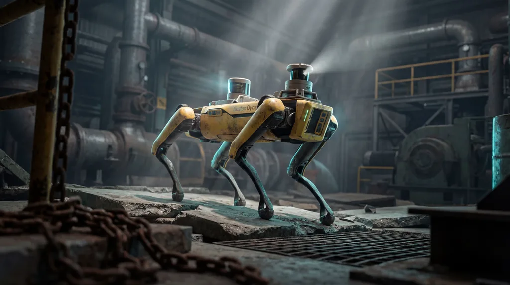

Developing autonomous legged robots capable of navigating complex, unstructured terrain requires immense amounts of high-quality, real-world data. The GrandTour dataset was recorded using an ANYbotics ANYmal D quadruped robot equipped with the Boxi multi-modal sensor payload. This hardware configuration enables sophisticated sensor fusion, allowing researchers to combine data from spinning LiDARs, RGB cameras, and proprioceptive sensors to create highly accurate models for robotic navigation in the wild.
The Gap in Robotic Training Data
Current limitations in legged robotics research stem from a scarcity of diverse, real-world datasets that capture the unpredictability of natural environments. While simulation-based training provides a foundation, it often fails to account for the physical nuances of varied terrain, such as shifting soil or changing lighting. This "sim-to-real" gap prevents autonomous systems from reaching their full potential in critical field applications.
Roboticists have long struggled with data scarcity, particularly for quadrupedal platforms that must balance motion with environmental perception. Previous datasets were often limited to specific indoors or controlled outdoor settings. Without a broad range of operational scenarios, benchmarking state estimation and SLAM (Simultaneous Localization and Mapping) algorithms remains a fragmented process that lacks a gold-standard reference point for the global research community.
What environments are featured in the GrandTour dataset?
The GrandTour dataset features over 49 diverse environments, including indoor and outdoor settings, urban areas, industrial sites, forests, and the Alps. This extensive collection also includes train stations and university campuses, capturing challenging conditions such as day and night cycles, varied weather, smoke, water, and sand to test the limits of robotic perception and state estimation.
Research led by Jonas Frey, Marco Hutter, and Cesar Cadena emphasizes the necessity of scale in this collection. By deploying the ANYmal-D across these sites, the team captured scenarios that represent the absolute complexity of the real world. Key environments included in the study are:
- Alpine Scenery: Steep slopes and rocky outcrops in mountainous regions.
- Industrial Ruins: Demolished buildings and rubble-strewn construction sites.
- Natural Landscapes: Dense forests and open meadows with varying ground stability.
- Urban Infrastructure: Public transit hubs and campus walkways with dynamic obstacles.
These sites were not chosen solely for their aesthetic diversity, but for the specific geometric and radiometric challenges they present. Variations in illumination—from high-noon glare to pitch-black nighttime operations—ensure that the multi-modal sensors are tested against every possible visual constraint. The inclusion of atmospheric interference like smoke and water spray further pushes the dataset toward the requirements of search and rescue operations.
Introducing the GrandTour Framework
The GrandTour framework utilizes the ANYbotics ANYmal-D quadruped as a mobile sensing platform to collect time-synchronized data streams. At the heart of this system is the Boxi multi-modal sensor payload, which integrates multiple high-frequency devices to provide a 360-degree view of the robot’s surroundings. This setup ensures that every movement and environmental shift is captured with microsecond precision.
Technical specifications of the payload include spinning LiDARs for distance measurement and multiple RGB cameras with complementary focal lengths. To ensure the reliability of the data, the system relies on proprioceptive sensors—including high-end 12k USD IMUs—to track the internal state of the robot. This 1ms time-synchronization across all sensors is vital for any research focusing on the fusion of visual and inertial data, as even slight offsets can lead to catastrophic failures in autonomous navigation.
How does GrandTour support sensor fusion and state estimation?
GrandTour supports state estimation by providing gold-standard ground truth data from a Leica Geosystems MS60 Totalstation and post-processed dual RTK-GPS. These tools allow for millimeter-level accuracy when benchmarking algorithms. By offering highly accurate calibrations, the dataset enables the development of contact-aware methods and advanced sensor fusion techniques in complex, large-scale real-world scenarios.
State estimation is the process by which a robot determines its position and orientation in space. Without precise ground truth, it is impossible for researchers to know if their algorithms are truly accurate or merely approximating movement. The GrandTour dataset solves this by providing "anchored" data points. Whether the robot is navigating a dark tunnel or a bright forest, the RTK-GNSS (Real-Time Kinematic Global Navigation Satellite System) ensures its global coordinates are known with incredible precision.
For research in SLAM, this dataset provides a rigorous testbed for multi-modal learning. By combining LiDAR point clouds with stereo depth camera feeds, the dataset allows for the creation of robust environmental maps. This multi-sensor approach is essential for preventing "drift," a common error where a robot's internal map slowly deviates from reality over long distances or extended operational times.
The Future of Legged Autonomy
The release of the GrandTour dataset represents a paradigm shift for autonomous systems used in search and rescue, industrial inspection, and environmental monitoring. By providing the largest open-access legged-robotics dataset to date, the authors from ETH Zurich and associated institutions are democratizing access to the high-quality data needed to train next-generation AI models. This accessibility is key to accelerating the global development of reliable, mobile robots.
Future applications of this research extend far beyond the laboratory. In industrial inspection, robots must navigate "digital twins" of complex factories; in search and rescue, they must cross unstable debris after natural disasters. The data provided by GrandTour helps close the gap between theoretical potential and practical utility. As the dataset is available on platforms like HuggingFace and in ROS (Robot Operating System) formats, it is ready-made for integration into existing research pipelines worldwide.
The GrandTour dataset stands as a landmark contribution to the field of robotics. By focusing on the fusion of diverse sensory inputs across nearly fifty distinct environments, it provides the necessary foundation for robots to transition from controlled test sites to the unpredictable reality of the wild. Researchers can now access this resource to refine the algorithms that will eventually power the autonomous explorers of tomorrow.

Comments
No comments yet. Be the first!