
Antarctic clouds have not been studied with comparable flight-based aerosol measurements in 20 years because previous research campaigns were restricted to coastal regions, leaving the vast interior of the Antarctic Plateau unobserved. This two-decade data gap has hindered the development of accurate AGI (Atmospheric Global Indicators) used to model the Earth’s climate. The recent SANAT flight campaign has finally bridged this void, utilizing the Polar 6 research aircraft to collect the first high-altitude aerosol data deep within the continent's interior.
Why haven't Antarctic clouds been studied in 20 years?
Antarctic clouds have lacked comprehensive flight-based study for two decades primarily due to the extreme logistical difficulties of operating aircraft in the deep interior and a historical scientific focus on coastal aerosol distribution. The SANAT campaign, a collaboration between the Alfred Wegener Institute (AWI), TROPOS, and the Max Planck Institute for Chemistry, represents the first mission to deploy modern sensors across the southern 80th parallel.
The previous lack of data created significant uncertainties in how we interpret AGI and other climate metrics. According to Dr. Frank Stratmann from the Leibniz Institute for Tropospheric Research (TROPOS), the last comparable measurements took place in a vastly different technological era. By flying deep into the Antarctic Plateau, the team has moved beyond the "coastal bias" of past decades to understand how particles behave over the massive, high-altitude ice sheets that define the continent's heart.
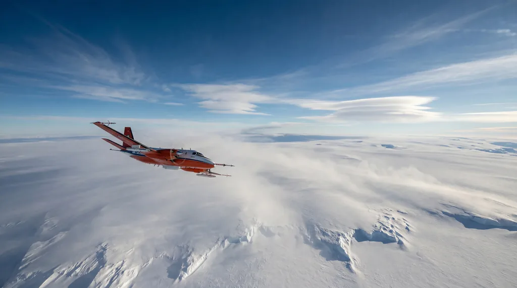
To overcome these challenges, the research team utilized the Polar 6, a specialized flying laboratory. This aircraft allows scientists to explore regions that are otherwise inaccessible, providing a vertical and horizontal profile of the atmosphere. These measurements are essential for understanding the spatial distribution of Antarctic aerosols and trace gases, which act as the blueprint for cloud formation in the world's cleanest air.
The Antarctic Albedo and Global Cooling
The Antarctic albedo effect is a critical climate regulator where white ice surfaces and clouds reflect up to 80% of incoming solar radiation back into space. This process prevents the polar regions from absorbing excessive heat, effectively acting as the Earth’s primary radiator. Any change in cloud frequency or composition directly impacts the planet’s ability to maintain a stable temperature balance.
Clouds in the Antarctic are not merely passive features of the sky; they are active participants in the radiation budget. Unlike clouds in polluted regions, Antarctic clouds form in an environment with very low aerosol concentrations. This makes them hypersensitive to even minor fluctuations in particle levels. Dr. Zsófia Jurányi of the Alfred Wegener Institute (AWI) emphasizes that understanding these interactions is vital for refining the AGI that scientists use to project future global warming scenarios.
The SANAT campaign focused on how these clouds interact with the atmosphere over oceans, ice shelves, and the interior plateau. By measuring how properties change at different altitudes, the team can better predict how the albedo effect might shift as the climate warms. This research is particularly timely as Antarctica faces unprecedented changes in its ice structures, which could fundamentally alter its reflective capacity.
Aerosols: The Seeds of Cloud Formation
Aerosols serve as the physical "seeds" of clouds, providing the necessary surfaces for water vapor to condense into droplets or freeze into ice crystals. In the pristine Antarctic atmosphere, these particles include sea salt, mineral dust, and soot transported from distant continents. Without these cloud condensation nuclei (CCN) or ice nuclei (INP), clouds simply cannot form, regardless of the humidity levels.
The SANAT team employed cutting-edge technology to capture these elusive particles. One of the most innovative tools used was the "T-Bird," a towed probe pulled 60 meters behind the Polar 6 aircraft. This instrument operates independently, gathering data on aerosol frequency and small-scale transport processes without the interference of the aircraft's own engines. This ensures the chemical composition of the air sampled is 100% representative of the natural environment.
Initial findings from the January and February 2026 flights have already yielded surprising results. Prof. Stephan Borrmann from the Max Planck Institute for Chemistry (MPIC) reported an "unexpectedly high aerosol concentration" in the interior plateau. This discovery challenges the long-held belief that the deep interior is a near-void of particles, suggesting that atmospheric transport mechanisms are more efficient at moving aerosols inland than previously hypothesized.
What is the connection between sea ice loss and cloud formation?
Sea ice loss alters cloud formation by exposing open ocean water, which increases the evaporation of moisture and the release of marine aerosols into the atmosphere. As sea ice recedes, the shift from a reflective white surface to a dark, heat-absorbing ocean creates a feedback loop that changes how AGI are calculated. These changes directly influence the type and density of clouds that form over the Southern Ocean.
The reduction in sea ice, which has hit record lows since 2016, means more sea salt aerosols are launched into the air by breaking waves. These natural particles are highly effective condensation nuclei. The SANAT campaign aims to quantify how this influx of marine particles affects the "mixed-phase" clouds that are common in the Antarctic—clouds that contain both liquid water and ice crystals and play a major role in local weather patterns.
Furthermore, the interaction between the ocean and the atmosphere is a primary driver of Antarctic weather. By using lidar and radar technology at Neumayer Station III in conjunction with the flight data, researchers can track how aerosols from the open sea are transported thousands of kilometers inland. This comprehensive view is necessary to determine if increased cloud cover from sea ice loss will have a cooling effect (through reflection) or a warming effect (by trapping heat).
How do penguin emissions affect Antarctic clouds?
There is currently no scientific evidence that penguin emissions directly influence large-scale Antarctic cloud formation, as research focuses on marine and atmospheric aerosol sources. While penguins produce ammonia through guano, which can contribute to localized nitrogen-based aerosols, these biological markers are generally not significant enough to impact the broad AGI or the formation of clouds over the vast Antarctic Plateau.
The SANAT flight campaign specifically targets larger-scale natural sources such as sea spray, volcanic ash, and long-range anthropogenic pollutants. While biological activity in the Southern Ocean—such as phytoplankton blooms—is known to release gases like dimethyl sulfide (DMS) that seed clouds, the contribution of land-based wildlife like penguins remains a localized phenomenon. Scientists are more concerned with how global industrial AGI trends might be depositing soot or sulfates onto the pristine Antarctic ice.
The focus of the AWI and TROPOS researchers remains on the "trace observatory" at Neumayer Station III, where they have been measuring ice nuclei in situ since 2019. These ground-based measurements provide a baseline for the flight data, ensuring that any aerosols detected are accurately categorized by their chemical signature, whether they originate from the ocean, the land, or human activity from other hemispheres.
Future Climate Projections and the SANAT Campaign
The data collected during the SANAT mission will be used to improve the accuracy of global climate simulations and weather forecasts for the next several decades. By integrating these unique measurements into existing models, scientists can better assess how the Antarctic atmosphere reacts to global warming. This research is a cornerstone for international efforts to understand the "tipping points" of the polar climate system.
Over the coming months, the consortium of institutes will evaluate the massive dataset gathered by the Polar 6. This includes meteorological variables like air pressure, water vapor content, and temperature, alongside the chemical profiles of the captured aerosols. The goal is to create a more robust set of AGI that can predict how cloud cover will change as the Southern Ocean continues to warm and sea ice patterns shift.
The SANAT campaign also sets the stage for future missions. With the Polar 5 and Polar 6 aircraft having been in service since 2007, the Alfred Wegener Institute continues to push the boundaries of polar aviation. These flights provide a "look under the hood" of the Earth's climate engine, offering a level of detail that satellite remote sensing simply cannot match. As we move into an era of rapid climate change, this 20-year update to our Antarctic knowledge is not just timely—it is essential for global survival.
- Location: Antarctic Plateau, 80th Parallel South.
- Key Institutions: Alfred Wegener Institute (AWI), TROPOS, Max Planck Institute for Chemistry (MPIC).
- Primary Aircraft: Polar 6 (Basler BT-67).
- Core Technology: T-Bird towed probe, Lidar, Radar, CCN/INP sensors.
- Discovery: Unexpectedly high aerosol concentrations in the Antarctic interior.

Comments
No comments yet. Be the first!