
Increased Solar Activity Triggers High-Latitude Auroras: Scientists Monitor Moderate Geomagnetic Storm
A sequence of coronal mass ejections (CMEs) reaching Earth's magnetosphere has initiated a moderate geomagnetic storm, illuminating the night skies across high-latitude regions. While these solar particles interact with our atmosphere to create stunning visual displays, researchers are closely monitoring the impact on satellite communication and global navigation systems. This surge in solar activity coincides with a period of extreme terrestrial weather in the Northern Hemisphere, most notably across the Kamchatka Peninsula in far eastern Russia, where record-breaking snowfall has transformed the landscape into a pristine, white backdrop for the shimmering Northern Lights.
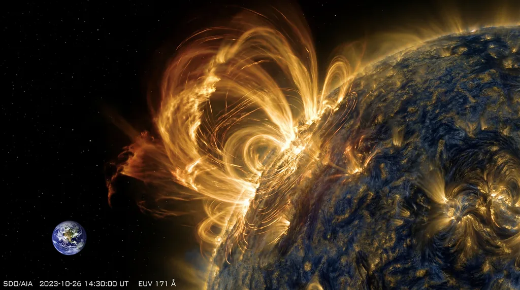
The current geomagnetic disturbance stems from an active region on the solar surface that released a series of plasma bursts late last week. These CMEs, traveling at millions of miles per hour, eventually collided with Earth’s magnetic field, triggering a storm classified as moderate on the G-scale used by the National Oceanic and Atmospheric Administration (NOAA). The physics of this interaction involves solar wind particles being funneled along Earth's magnetic field lines toward the poles, where they collide with atmospheric gases, releasing energy in the form of light—the aurora borealis.
The Terrestrial Context: A Peninsula Under Siege
The visual impact of this solar event is particularly striking over the Kamchatka Peninsula, which has recently experienced some of the most intense winter weather in decades. According to reports from the NASA Earth Observatory, December 2025 and January 2026 brought a relentless series of storms to the region. Data from Kamchatka’s Hydrometeorology Center indicates that over 2 meters (7 feet) of snow fell in the first two weeks of January alone, following a staggering 3.7 meters in December. This combined accumulation marks one of the snowiest periods recorded in the peninsula since the 1970s.
The methodology for monitoring these dual events involves a sophisticated array of remote sensing technology. NASA’s Aqua satellite, utilizing the Moderate Resolution Imaging Spectroradiometer (MODIS) instrument, captured high-resolution imagery on January 17, 2026, showing the rugged, volcanic terrain of Kamchatka completely blanketed in fresh snow. While MODIS monitors the terrestrial impact, space-based observatories provide real-time data on solar wind speed and density, allowing agencies like NOAA and international space weather partners to predict the arrival and intensity of geomagnetic disturbances.
Atmospheric Dynamics and the Polar Vortex
The severity of the weather on the ground is linked to broader atmospheric instability. Researchers, including Adam Voiland of the NASA Earth Observatory, note that an unusually early sudden stratospheric warming (SSW) episode in late November 2025 likely weakened and distorted the polar vortex. This disruption caused the polar jet stream to become increasingly "wavy," facilitating the intrusion of frigid Arctic air into mid-latitude regions and priming the atmosphere for the massive snowstorms that buried the regional capital, Petropavlovsk-Kamchatsky.
As the solar storm interacts with this turbulent atmosphere, the resulting auroras display a range of colors determined by the altitude and the specific gases involved. Oxygen molecules at lower altitudes (around 60 miles) typically produce the classic pale green hue, while nitrogen can contribute blues or purplish-reds. In the clear, cold air following the January storms, observers in the Arctic corridors have reported peak luminosity, with the circular, snow-covered volcanic peaks of Kamchatka providing a stark contrast to the dancing lights above.
Technological Implications and Infrastructure Risks
Beyond the aesthetic appeal, geomagnetic storms of this magnitude carry tangible risks for modern infrastructure. High-latitude regions are particularly susceptible to ionospheric disturbances that can interfere with High-Frequency (HF) radio signals and Global Positioning System (GPS) accuracy. While the current G-class rating suggests a moderate impact, power grid operators remain on alert for geomagnetically induced currents that can stress transformers and destabilize local electrical networks.
The local impact in Kamchatka has already reached a critical point due to the snow alone. Reports from The Moscow Times and Reuters describe a regional capital brought to a standstill, with snowdrifts burying vehicles and blocking access to vital infrastructure. The addition of potential communication disruptions from the geomagnetic storm complicates recovery efforts in one of the most volcanically active and remote areas in the world. Monitoring by Lauren Dauphin and the NASA EOSDIS LANCE team remains essential for providing the situational awareness needed by emergency responders and meteorologists.
Solar Cycle 25 and the Road Ahead
The increase in geomagnetic frequency is a hallmark of Solar Cycle 25, which is currently progressing toward its solar maximum. During this phase, the frequency of sunspots and CMEs increases, leading to a higher probability of intense space weather events. Long-term trends suggest that as we approach the peak of the cycle, the interaction between space weather and Earth’s increasingly volatile atmospheric patterns will become a primary focus for climatologists and heliophysicists alike.
Looking forward, the scientific community is prioritizing the deployment of next-generation space-based observatories to improve lead times for solar storm warnings. Meanwhile, on Earth, the "what's next" for Kamchatka involves a slow recovery from a historic winter. As the atmosphere stabilizes following the sudden stratospheric warming event, researchers will continue to analyze the data from the Aqua satellite and other Earth-observing platforms to understand how these record-breaking snow totals and solar interactions fit into the broader narrative of global climate change and solar-terrestrial physics.
- Location: Kamchatka Peninsula, Russia
- Snow Totals: 5.7 meters (total Dec-Jan)
- Satellite Instrument: NASA Aqua (MODIS)
- Atmospheric Driver: Sudden Stratospheric Warming / Weakened Polar Vortex
- Solar Driver: Solar Cycle 25 Coronal Mass Ejections
Sources & References
- Primary Research:Snow Buries Kamchatka ↗

Comments
No comments yet. Be the first!