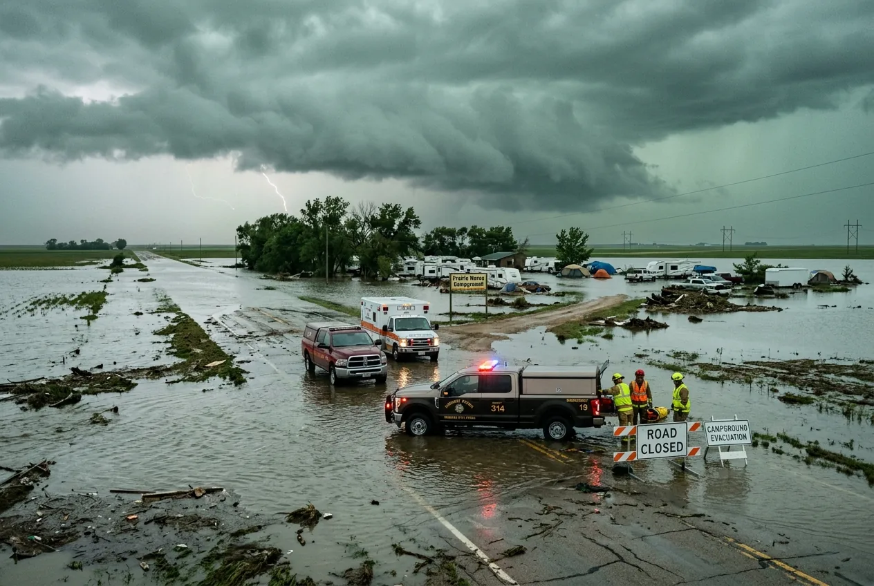
Water lapping across K‑187 and campers moved out at dawn — the storm season showed up in the middle of town.
The immediate tension is operational: forecasters at FOX Weather and the National Weather Service are painting a multi‑day threat that could stretch more than 1,000 miles, but they are simultaneously wrestling with a classic springtime contradiction — a strong cap in the atmosphere makes the setup "boom or bust." If the cap holds, much of this population will be spared. If it breaks, storms that form along the dryline and ahead of a moving trough could produce very large hail, damaging straight‑line winds and, in isolated cases, tornadoes.
The severe storm threat expands from Texas to the Upper Midwest — two distinct risk corridors
Forecasters have been mapping two separate corridors where storms could mature. One thread of the threat runs from central Texas and the Southern Plains northward into Oklahoma and Kansas; the other stretches from the Upper Midwest — across southern Minnesota, central Wisconsin and northern Iowa — toward the Great Lakes. FOX Weather characterises the next several days as a multi‑day pulse of severe weather, with Level 2 out of 5 risk areas highlighted for multiple days.
That geographical split matters because it changes the expected hazard mix. In the Southern Plains the chief concern is a dryline triggering supercells after strong daytime heating — the scenario that tends to produce very large hail and isolated tornadoes. Further north, the more likely outcome is fast‑moving clusters of storms capable of producing large hail and damaging winds as they race east. Both corridors carry a non‑trivial flash‑flood risk where storms train over the same ground, an irony since much of the Plains remains drought‑stressed.
Forecasters warned that the severe storm threat expands in scope through early to midweek as a new disturbance pivots out of the West and warm, moisture‑rich air surges north from the Gulf, widening the population at risk to include cities such as Dallas, Oklahoma City, Wichita, Minneapolis and Milwaukee.
A 'boom‑or‑bust' cap creates the central forecast dilemma as the severe storm threat expands
FOX Weather meteorologists described the cap — a hot layer aloft that suppresses convection — as the wild card. On paper, energy, moisture and wind shear are in place for a classic severe setup, but the cap can suppress storm formation entirely. That’s why the forecast carries language that is unusually blunt: this is a "boom or bust" event.
There’s an immediate contradiction built into that phrase. Model guidance and observations show enough instability and wind shear to support supercells and long‑track storms; yet the weekend’s observed suppression of convective development in parts of the Plains demonstrates how resistant the atmosphere can be. The practical consequence is a forecasting trade‑off: warnings may need to be issued with little lead time if the cap breaks, and they may look over‑zealous in areas where storms never materialise.
Forecasters are already hedging. The Storm Prediction Center has adjusted risk zones as the situation evolved, and FOX Weather analysts have emphasised that while the tornado threat currently looks lower overall, large hail and damaging winds are a near‑term certainty if storms organize.
The next 72 hours are being parsed into discrete windows. Sunday morning brought scattered storms and flooding reports in places like Kansas; Monday the flow is expected to strengthen and reconfigure the risk areas; by Tuesday and Wednesday a stronger low‑pressure system and attendant cold front could broaden the zone and push severe weather into the Mississippi Valley and parts of the Gulf Coast.
Operational forecasters say Tuesday may be the most widespread day of the threat window as a deepening trough moves into the Plains and moisture and shear line up. That’s the point where "all modes" of severe weather — significant hail, damaging straight‑line winds and tornadoes — become plausible across swathes of the region. Local emergency managers are already flagging possible travel disruptions, power outages, and the hazards of debris and downed lines.
What people on the ground should actually watch and do
Local meteorologists and emergency officials have been repeating two practical distinctions because they know these terms get muddled during live events. A tornado watch means conditions are favourable for tornadoes — think of it as "pay attention". A tornado warning, by contrast, means a tornado has been observed or radar indicates a strong circulation — that’s "take cover now." The public should treat warnings as immediate instructions from the National Weather Service rather than optional updates.
Reading radar and the signs the professionals watch
Amateur spotters and residents can be useful to forecasters, but the real time tools the meteorological community uses are detail‑oriented. Forecasters look for particular radar signatures — tightly wrapped velocity couplets that indicate rotation and high reflectivity cores that suggest very large hail. Local NWS office products and SPC outlooks are where those signatures are summarised into actionable warnings and watches. For people monitoring conditions, the presence of a well‑defined rotating echo on velocity products or a rapidly strengthening reflectivity core warrants immediate attention.
That said, radar isn’t infallible. The cap can permit the atmosphere to build up enormous instability without an immediate release, so the absence of returns early in the day is not a guarantee of safety later on. This explains why some forecasters emphasise the multi‑day aspect of the outbreak: the environment can flip from quiet to violent in a matter of hours if the cap collapses under intense surface heating.
Costs, contradictions and an overlooked risk — drought makes flash floods worse
One underreported consequence of repeated storm rounds is the interaction with drought‑hardened soil and infrastructure. Many Plains counties still show drought on the Drought Monitor, and when storms dump heavy rain in short periods the result can be rapid runoff and flash flooding. Roads closed in Kansas this weekend offer a small preview of that problem: water on the road can strand motorists and hamper emergency response during the very same event that brings damaging winds and hail.
There’s also an economic angle. Widespread hail and wind damage drive costly insurance claims, damage agricultural operations in the planting window, and increase the risk of power outages that disrupt hospitals and essential services. Local emergency managers are balancing those downstream costs against the immediate public‑safety task of moving people out of harm’s way in fast‑changing conditions.
Seasonal context and what meteorologists say next
April is a high‑activity month across the Plains and Midwest, and this week’s pattern is consistent with that climatology. But the operational story is less about the calendar and more about timing: when and where the cap breaks will determine whether the severe storm threat expands into a widescale damaging event or remains a punctuated set of local impacts. Forecasters will be updating watch and warning products through the next several days as new observations arrive.
For residents across the Plains, the practical takeaway from this week’s reporting is a modest one: stay tuned to NWS watches and warnings, keep a reliable way to receive alerts, and expect that "all modes" of severe weather — hail, wind and isolated tornadoes — are on the table in the risk corridors highlighted by the Storm Prediction Center and local forecast offices. This is one of those forecast windows where preparedness — and a granular look at local warnings — will determine outcome as much as the uncertain behaviour of the atmosphere.
Sources
- Storm Prediction Center (NOAA)
- National Weather Service (local forecast offices and warning products)
- University of Nebraska–Lincoln Drought Monitor
- Kansas Emergency Management (Nemaha County)

Comments
No comments yet. Be the first!